Konstantinos Karantzalos received his engineering diploma from the National Technical University of Athens (2000, NTUA, Greece) and his PhD (SRSE, NTUA) in collaboration with Ecole Nationale de Ponts et Chaussees (CERTIS/Imagine, ENPC, France). His PhD thesis was entitled "Automatic feature extraction from aerial and satellite imagery with computer vision techniques".
In 2007, he joined the Department of Applied Mathematics at Ecole Centrale de Paris (France) as a postdoctoral researcher working with Prof. Nikos Paragios (Center for Visual Computing & GALEN group ECP/Inria at the Saclay).
Dr. Karantzalos is currently an Associate Professor at the National Technical University of Athens, joining the Remote Sensing Laboratory (RSLab, Head: Prof. Demetre Argialas) of the Department of Topography. He is also occasionally affiliated with the Institute of Communications and Computer Systems (ICCS) and the Athena Research Center.
His teaching and research interests include earth observation and remote sensing, geospatial big data and analytics, computer vision and machine learning, enviromental monitoring and precision agriculture. He has numerous publications in international journals and conferences and a number of awards and honors for his research contributions.
Research/Work experience: 17 years of research experience, involved with more than 19 EU and national excellence/competitive research projects as a principal investigator and as a researcher towards the design, development and validation of state-of-the-art methodologies and cutting-edge technology in Geomatics, Earth Observation and Computer Vision; CTO at Brainomix Ltd. (2009-2012); Curently coaching/advising a couple of Greek Start-ups; Survey Engineer at the construction of the New Athens International Airport, “El. Venizelos” for the Joint Venture J&P Hellas and Helliniki Texnodomiki at the “Extension of Taxiway C and Olympic Aviation Home Base Apron” (2000-2002).
Professional Activities: Dr. Karantzalos serves as a Scientific/Program Committee Member in international conferences and as a reviewer in top rank international journals (e.g., Transactions on Pattern Analysis and Machine Intelligence, IEEE; Transactions on Geoscience and Remote Sensing, Transactions on Image Processing, IEEE; Pattern Recognition Letters, Elsevier; Journal of Photogrammetry and Remote Sensing, Elsevier; Selected Topics in Applied Earth Observations and Remote Sensing, Journal of Selected Topics in Applied Earth Observations and Remote Sensing, IEEE; International Geoscience and Remote Sensing Symposium, IEEE). Dr. Karantzalos serves as Evaluator/ Panel Member for EU and national research programmes and currently Co-chairing the ISPRS Commision III, WG III/4 on Hyperspectral Image Processing.
News
Projects (current):

2019 - GERANIIUM: Generative Artificial Intelligence for High Performing Inversion Models, ESA

2019 - NEANIAS: Novel EOSC services for Emerging Atmosphere, Underwater and Space Challenges, H2020

2020 - OLEAS: Safer and High-nutritional Olive cultivation with Remote Sensing and Precision Agriculture, EIP-AGRI, RDP

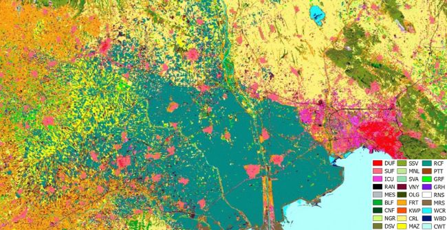
2018 - aMAP: Mapping Annually Land Cover/Use and Crop Types from Harmonized High Resolution Satellite Copernicus Data, High Performance Computing - Production Project, Access to ARIS @HPC GRNET
2019 - UAVspec: Inspection and Assessment Services for Unmanned Aerial Systems (UAS) and their Onboard Sensor Suite

2018 - TAGs: Technological and Business innovation services to stimulate the local Agro-food ecosystems and to support a Cross Border Collaboration among Local Action, Interreg V-A Greece-Italy Programme 2014-2020
2018 - SOUP : SOilless Culture Upgrade Exploit Robotic System and Artificial Intelligence Technologies towards Decreasing Costs in Hydroponic Farming, EU ERDF & Greek General Secretariat of Research and Technology.
2018 - VirtualDiver: Development of an Integrated Interactive Platform for Underwater Virtual Reality Experience for Culture and Tourism Industries, EU ERDF & Greek General Secretariat of Research and Technology.